August 2026. Haslemere, Surrey.
The signal box at Haslemere Station, located on the platform and decommissioned in June as part of the Farncombe to Petersfield re-signalling programme, has been handed over to a local trust to be run as a museum. The newly restored signal box will be run by the Haslemere Signal Box Trust. Over the past three months it has been restored to its traditional Southern Railway appearance as more than 35 volunteers from South Western Railway and Network Rail have helped with the refurbishment. Ken Griffiths, Chair of the Haslemere Signal Box Trust, said: “Thanks must be given to all the volunteers who helped us renovate the box and fit out the museum. They included Network Rail and South Western Railway employees and the local pool of volunteers from Haslemere and the surrounding district.” (Industrial Heritage Networks)
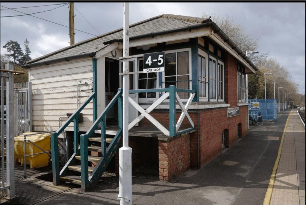
Photo: courtesy of The Haslemere Signal Box Educational Charitable
Incorporated Organisation
August 2026. Chichester to Midhurst, West Sussex.
Eagle-eyed ramblers on the Club’s successful West Dean to Singleton walk on 12 August spotted the official notice from South Downs National Park Authority headed ‘Construction of the next section of Centurion Way and closure restrictions’ (these restrictions no longer apply as certain works have been completed). This will extend the route from Milk Halt to Littlewood with a further extension to join up with the South Downs Way, planned for 2026/27, with further expansion to Cocking. Full details can be found at southdowns.gov.uk – FAQ section. There are no plans to open up any of the three tunnels. This new section will continue the walking and cycling route around Wellhanger Copse (National Trust owned) to Littlewood Farm, and on to Cocking Hill Farm on the South Downs Way, using the former trackbed where possible. It is then a relatively short walk on public footpaths to Cocking, thence to Midhurst by bus. It is hoped to be able to organise a Club walk on the new extension, with a possible visit to the former Cocking station, as well as what remains in Midhurst. Further news on opening, and a date for Railway Ramblers, will be made online and in Ramblings. (Chris Witt)
August 2026. Hawes, Yorkshire.
Yorkshire Dales National Park (YDNP) is advertising for a Project Manager to lead the next stage of their conversion of the Garsdale to Hawes trackbed into a multi-use route. The job specification indicates that the successful candidate will work alongside local communities and landowners ‘to help bring to life a trail that connects people with nature, promotes active travel and enhances access to one of Britain’s most beautiful landscapes’. This is interesting in the light of landowner opposition to the conversion, as reported in previous issues of this magazine. (YDNP)
August 2026. Heighington, Yorkshire.
Here’s an opportunity to go digging at what is possibly the world’s oldest open railway station! Join Tees Archaeology on a dig at Heighington Station this September, as part of the Friends of Stockton & Darlington Railway Festival. Uncover the past and learn new skills. In the first two weeks of September, Tees Archaeology will be doing a community excavation at Heighington Station, the oldest passenger station in the world! You don’t need any prior experience…just come along and join in with the dig. The organisers provide all tools, gloves, water, hot drinks and their famous Scooby snacks! You just need sturdy footwear, a raincoat, a packed lunch and a good sense of fun. (Dr Emma Watson, Tees Archaeology; Jane Ellis)
July 2026. Bennerley Viaduct, Nottinghamshire/Derbyshire.
The Visitor Centre and café has been opened at the viaduct as part of the project celebrating its heritage and significance to the area. The visitor centre includes displays from the viaduct’s 150-year history and is clad in Corten steel, inspired by railway carriages and designed to reflect the viaduct’s industrial heritage. The restoration project has faced several challenges, including repeated work on the entrance ramp, which delayed the opening of the centre, but it is now open and proving extremely popular (BBC; Alan Green)
July 2026. Midgeholme, Cumberland.
Further to the news and campaign letter published in the previous two issues of RR regarding a damaged section of the Lord Carlisle Trail, a member of the community has negotiated the purchase of the land from the person responsible for the damage. The agreed price was considerably lower than the amount requested for a community purchase and did not allow the owner to profit from the sale. A plan is now being drawn up for the restoration of the path, with advice sought from North Pennines National Landscape and RSPB Geltsdale to improve the ecological value of the site. Campaigners also want to reinstate a missing bridge a couple of miles to the west, at Tindale, which is essential for reconnecting the whole route. (Lord Carlisle Heritage Trail/Jeremy Ancketill; RR)
July 2026. Little Bytham, Lincolnshire.
Although the old Ticket Office, the sole remaining relic of Little Bytham (GNR) station, sold recently at auction for £112,000, just within the guide price range, it is not known whether or not the crowdfunded Community Interest Company, a group trying to save the building for posterity, was the successful bidder. It was feared that the building would be demolished and houses built on the site if a developer bought it. Little Bytham is a closed station on the East Coast Main Line, near where Mallard set the world speed record for a steam locomotive in 1938. Just across the road from the ticket office however, is what was the terminus for the private Edenham and Little Bytham Railway. Latterly a public house, the historic edifice now appears to stand empty and unused. (RR)
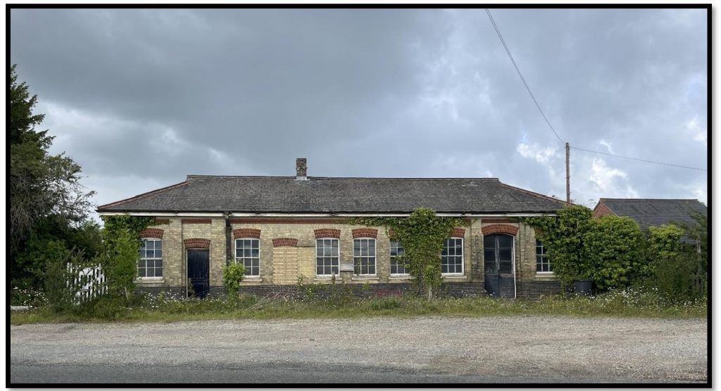
Photo: BTG Eddisons Property Auctions
July 2026. Braughing, Hertfordshire.
The infillers of National Highways are back, this time at a bridge overlooking the restored station of Braughing in Hertfordshire, on what was the Buntingford branch. It was originally built in timber and opened with the line in 1863, but it was reconstructed with steel girders and brick abutments in 1920. Although the line closed to freight services in 1965, the bridge still carries the B1368 road over the old trackbed. The structure forms part of the Department for Transport’s Historical Railways Estate, managed by National Highways (NH).
Engineers advised NH to undertake repair works to ‘widespread areas of heavily corroded metal’ more than four years ago, since when nothing has been done. Having failed to safeguard the bridge, NH is now proposing an infilling scheme involving hundreds of tonnes of foamed concrete, for which planning permission is needed but has not yet been applied for. More than 1,600 people have signed a petition to save the bridge from infilling, acknowledging its importance as part of a group of heritage assets along with Braughing Station, located next to it.

Photo: The HRE Group
Two other former railway structures managed by National Highways are currently closed due to their deteriorating condition. Moss Lane Bridge near Formby is now proposed for demolition and replacement, whilst a scheme to infill Stow Maries Bridge near Chelmsford in Essex – which is located within a nature reserve – has recently been granted planning permission. (HRE; RR)
June 2026. Bembridge, Isle of Wight.
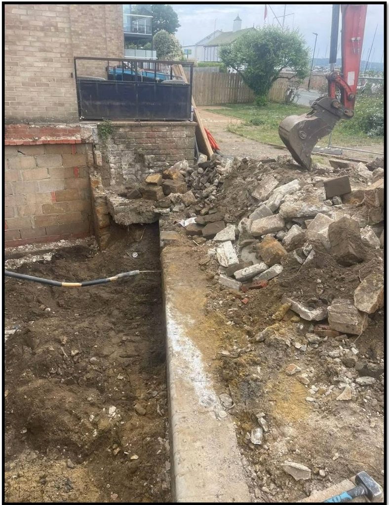
There is a very good YouTube channel called ‘Wight Wanderer’ that posts videos most weeks ‘devoted to telling the history of the Isle of Wight, from its abandoned railways and historic relics to its hauntings and connections with witchcraft’. Its main interest is the railways of the Island and it recently posted a short video showing the remains of a short section of Bembridge Station platform which had been uncovered by builders during some work being done on one of the town houses that now stands on the site. Steve Wall reports: ‘I visited the site and it does appear that the whole platform could well still exist under patios and gardens. Unfortunately, the remains in this photograph have now been dug out and taken away. However, as we discovered on a Railway Ramblers walk many years ago, the gateposts to the old station yard do stand, in situ, to this day.’ (Steve Wall)
June 2026. Abbots Ripton, Huntingdonshire.
The very attractive and much extended station house at Abbots Ripton appeared to remain on sale as this magazine went to press, priced at £595,000. Five bedrooms, a double garage, an outbuilding and a large garden to enjoy. Oh, and the East Coast Main Line passing within a few feet. What is curious is that the house is situated some distance away from the station site, at which nothing remains. (Mick Butler)
June 2026. Riddings Viaduct, Anglo-Scottish Border (Dumfriesshire/Cumberland).
The major restoration by National Highways of Riddings Viaduct on the former Langholm branch on the Anglo-Scottish Border, which we reported last year in RR No. 185, has now been completed. The structure is now looking spick and span. The works included replacement handrails the whole length of the viaduct. As you will see in the photo, these are so shiny and bright that they can be seen from several hundred yards away, and their silvery appearance is somewhat bizarre atop the red sandstone listed structure. Somewhat ironic that they have been put in place where the public has no access, but at least they’ll be there for the safety of the regular inspection and maintenance teams. No reply was ever received by the Chair of the Langholm Walks Group to his enquiry to National Highways about possible public access.
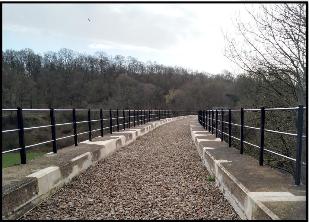
At least the renovated steps alongside the viaduct, which were for access for the restoration works, have been left in place, allowing walkers to get down to the riverbank and view the viaduct from underneath. (Alan Williams)
May 2026. Rothes to Craigellachie, Morayshire/Banffshire.
The Rothes Way is a community-led project which aims to provide a multi-use path linking Rothes and Craigellachie, which will for the most part follow the line of the former Great North of Scotland Railway and provide an off-road alternative to the A95/A941. It also provides a link to the Speyside Way at Craigellachie via the cast iron Telford’s Bridge. The railway viaduct was demolished some time after the line closed in 1968. Thus far the path covers the first two miles south out of Rothes, and sticks to the trackbed as far as Bulwark Cottage, where the line has been swallowed up by the main road. From here to the site of Dandaleith Station, a new path has been built, and then there’s a gap of about 100 metres, until the old road to Telford’s Bridge can be taken. It does look as if the line, albeit overgrown and in trees, could be followed on the opposite side of the main road as far as the River Spey and the site of the demolished viaduct. As for the Rothes Way, once in Craigellachie, a footpath goes under the A95 road bridge and connects to the Speyside Way, the long-distance footpath between Buckie and Aviemore. (RR)
May 2026. Carmarthen to Ffairfach, Carmarthenshire.
The Tywi Valley Path is now fully open and looks to be a worthy addition to the disused railway portfolio. It runs for about 13 miles from Abergwili just north of Carmarthen (and near the southern terminus of the Gwili Steam Railway) to Ffairfach (which has an open station on the Central Wales Line). The path largely follows the route of the old LNWR Central Wales & Carmarthen Junction Line. The stations at Golden Grove and Drysllwyn are still visible, although it is sad that the crossing gate on the eastern side of the road at the latter location has been demolished to accommodate the path. A railway bench, station sign and a section of platform remain at Nantgaredig. The path includes two new river crossings: a 64m-long footbridge over the River Cothi at Nantgaredig and near Llanegwad, a 57m-long steel bridge over the River Tywi (Towy in English), which is the longest river flowing entirely in Wales. (Chris Parker; RR)
May 2026. Buxton to Matlock, Derbyshire.
Feasibility studies come and go without rail reinstatement being seriously considered yet one has now been formally submitted to the Department for Transport for review, in regard to the line between Buxton and Matlock in Derbyshire. The study has been passed via the Better Value Rail Working Group, comprising the DfT, Network Rail and the Office of Rail and Road. RR members will know that much of the Buxton – Matlock trackbed is currently occupied by the spectacular Monsal Trail. Rail UK reports that ‘the submission marks a significant milestone for the project and confirms that no prohibitive technical, environmental, planning or delivery barriers have been identified at feasibility stage that would prevent the corridor progressing to the next phase of development, a Strategic Outline Business Case’.
Driving the study is the concern to meet carbon saving targets in the face of increasing road congestion, given that the vast majority of visitors to the Peak District National Park arrive by car. The report also highlights the ‘sensitive environments’ of which the Park comprises. Alongside transport benefits the study claims a reinstated Peaks and Dales Line could support sustainable access to new homes built on brownfield sites outside the Park. The proposal confirms that only around 11½ miles of railway would need to be completely reinstated, although other sections would require upgrading.
What of the Monsal Trail? The study says the path can be ‘enhanced’ rather than displaced, presumably running alongside the reopened line, at least in part. Quite what the authorities would make of the tunnel sections in this regard is open to question. The project has secured formal cross party parliamentary support, with more than twenty-six MPs across the East Midlands, North West and South Yorkshire having signed a joint letter of support to the Minister for Rail. Derbyshire County Council was expected to endorse further consideration of the proposal at its May meeting. (Rail UK; Forgotten Relics)
May 2026, Middleton, Lancashire.
Plans to restore the Grade II listed Th’iron Donger or Scowcroft Bridge in Middleton, with particular regard to its decorative panels, have been approved. The bridge carried the Leeds – Manchester line over the Rochdale Canal and is located around 500 metres north of Mills Hill Station. Originally built in 1863, the bridge was designed as a single-deck structure and was made from stone, cast iron and iron beams with distinctive decorative features. A second deck was added later, which still carries the railway from Manchester to Wakefield.
Some of the decorative features were removed in 2020, after severe deterioration made them unsafe, while the remaining decorative areas were removed in 2024, in order to prevent further damage and potential collapse. Engineers plan to use modern cast iron, which is easier to maintain than the original cast iron and can create an exact replica of the original features. (The Oldham Times; Forgotten Relics)

May 2026. Grantown-on-Spey, Morayshire.
An electoral manoeuvre or a genuine offer? If it returns to power, the Scottish National Party says it will undertake a scoping exercise to assess the viability of the Strathspey Railway’s long-held ambition to reach Grantown-on-Spey, which lies three miles north of its present terminus at Broomhill. The main obstacles are the River Spey and the A95, both of which would require new bridges to be constructed. The Highland Railway’s station site is mainly occupied by a timber merchant, although the station house survives, from where a footpath uses the trackbed heading north, becoming the official Dava Way a little further on. Meanwhile, across the river, the Grantown East Heritage and Cultural Centre uses the site of the ex-Great North of Scotland station, although the carriage that used to sit on some track has been removed by the new owners of the site (see photo on previous page when said carriage was in situ). (The Herald; Forgotten Relics)
May 2026. Fawley Branch, Hampshire.
Plans to reinstate passenger rail services on the Fawley branch in Hampshire have been rejected by a government regulator. Alliance Rail Ltd applied in 2025 to run trains between Marchwood and London Waterloo. However, the Office of Rail and Road (ORR) said it had concerns about network capacity, the firm’s future performance, the need for infrastructure and the scheme’s financial viability. Alliance Managing Director Ian Yeowart said: ‘We have never previously had reason to publicly comment on ORR rejection letters, but the content of this decision letter from the ORR is shoddy, unevidenced and, concerningly, factually incorrect in many areas‘. ORR, on the other hand, say they are ‘satisfied our decision to reject this application, on multiple grounds, is clearly supported by the evidence provided to us by Alliance and Network Rail’. Previously, the firm said it had developed a workable timetable and confirmed that its Class 769 trains would perform at the route’s full line speed. However, in its decision letter, the ORR said there is not enough capacity on the relevant part of the network for the application to be approved. It added: ‘The lack of available capacity (track and station) and uncertainty over the ability of the rolling stock to perform as required in the timetable means this application would introduce risks to railway service performance rather than improving it’. Marchwood signalling facilities would have needed upgrading and a new station required at Hythe. The aim was for one two-carriage diesel train running every 30 minutes to Southampton Central. A parallel plan to build 1,500 homes on the site of the former Fawley Power Station, which had been approved, was withdrawn in 2024. (BBC; Forgotten Relics)
April 2026. Somerset.
Somerset Council ratified its local transport plan in mid March and this included a commitment to set aside up to £730,000 over the next two years to help complete walking and cycling routes across rural parts of the county. This is due to the constraints around government grants, the majority of which are focused on urban parts of the county, with almost no money being set aside for rural areas. The current commitment, therefore, is based on the Strawberry Line and the wider Somerset Circle. When complete, the Somerset Circle will provide a 76-mile traffic-free circuit linking the north Somerset coast (including Weston-super-Mare and Clevedon), Bristol, Bath, the Mendip Hills and Shepton Mallet. More than two-thirds of the route is currently in place, including the Bristol and Bath Railway Path, the Two Tunnels Greenway in Bath and the Colliers Way to Radstock (which also continues on a spur out towards Frome). The Strawberry Line forms a key component of the Circle, running uninterrupted from Yatton Railway Station to Labourham Way in Cheddar, and will eventually reach all the way to Collett Park in Shepton Mallet.
The funding will be awarded to registered charity Greenways and Cycle Routes, which has been working since 2016 to deliver new rural active travel links. In addition to new sections of the Strawberry Line, the organisation has helped develop the Windsor Hill Greenway north of Shepton Mallet as well as new paths across Glastonbury. Mick Fletcher, chairman of the Strawberry Line Society, commented: ‘We can’t be too specific about the exact route we intend to take for the remaining sections until all landowners have signed on the dotted line. However, it is clear where the gaps are: Shepton Mallet to Wells, Wells to Easton, Westbury-sub-Mendip to Rodney Stoke, and Draycott to Cheddar’. RR members will be interested to hear his remark that ‘we are not dogmatic about sticking to the railway track, although where it is possible that has obvious advantages’. The Strawberry Line Society has been pushing the Historic Railways Estate (HRE – part of National Highways) to open up an arch of Stump Cross Bridge under Ridge Road, enabling path users to pass safely underneath the busy road on their way towards Wells. Following public criticism of HRE’s lack of progress in mid February, Mr Fletcher said that ‘things have started to move forward sensibly’ on this particular project. (Somerset County Gazette; Forgotten Relics)
March 2026. Shepton Mallet, Somerset.
As of March 2026 Bath Road Viaduct on the ex-Somerset & Dorset Joint Railway remains fenced off. Whilst the structure has acquired a tarmac path the formation to the east has not been converted at this moment in time. (Phillip Earnshaw)
March 2026. Breamore, Hampshire.
The overbridge next to the restored station is being repaired following a partial collapse. The footpath which utilises the formation at this point is therefore closed and likely to remain so until at least July (according to the Hampshire County Council website). Breamore was on the LSWR line from Salisbury to West Moors. (Phillip Earnshaw)
February 2026. Brampton, Cumberland.
Around 125 local residents attended a public meeting in early February near Brampton in Cumberland after concerns were raised about building work taking place on a popular local footpath which uses part of the trackbed of the long-defunct Lord Carlisle’s Railway. The land, located on the west side of Whites Cut, Midgeholme, near Lambley, was formerly owned by Sustrans and sold at auction in November last year. (Sustrans itself has recently rebranded as the rather cumbersome Walk Wheel Cycle Trust (WWCT). To his credit, the new landowner attended the meeting and apologised for any damage he had done to the site but claimed that he did not need planning permission for the work he was undertaking. This is disputed by local councillors who say that, due to historic coal mining in the district, expensive ground surveys have to be carried out before any such work can be started.
The landowner’s eventual plan is to build a property and workshop on the land. He added that he was carrying out the work in good faith and was trying to improve the site. Due to previous neglect of the site, he said flooding had occurred when he tried to clean out four blocked water courses and that this had led to more material being moved than originally anticipated. Apparently, he then offered to sell the land to the local community but ‘got laughed out of the village hall‘. His offer of £50,000 was more than twice what he paid for it, however.
Lord Carlisle’s Railway was one of Britain’s earliest lines with its origins dating back to wooden waggonways at Tindale Fell in the 1770s, with a through line to Brampton completed in 1798. Some of the route is used as a public footpath but the landowner said he had offered a strip of land on the edge of the site which could also be developed as a footpath and cycle route. He said: ‘So the public’s still got the use of it and obviously that’s a gesture of goodwill on my behalf’.
Cllr. Dobson said if any further work was attempted in the area he would take steps for Cumberland Council to issue a temporary stop notice. He added that he was working with the local community to try and establish the former railway line as a public right of way and locals were trying to nominate it as a community asset, and that there was interest in purchasing the land. In his letter to the WWCT, Cllr. Dobson wrote: ‘I am deeply troubled that a charity whose stated purpose is to ‘make it possible for every one of us to roll, ride, amble, gambol, stride, trek and tread’ and ‘to work with communities to effect change on the ground’ could dispose of this land…without any consultation with the local authority or with the communities directly affected‘. In the last few days the news hit the national press but it was somewhat surprising to see the following purple prose in the Daily Telegraph’s headline: Beauty spot turned into ‘bombsite’! While pictures do show the bridleway churned into mud, that can easily be rectified and the path restored.
What is of wider interest to Railway Ramblers is the role of WWCT/Sustrans in this and their policies regarding the development or disposal of land in their possession. A spokesman offered the rather weak excuse that they did not have 25 the ‘full facts about the use of the land previously’, adding that the planned east west link for the National Cycle Network, which was the reason the land had been purchased by the charity in the first place, had not proved achievable. The spokesman also said that the charity has a ‘legal obligation to sell land for (the) best value’, which is exactly the same rationale used by Railway Paths Ltd. when they sold a piece of trackbed at Threlkeld near Keswick a few years ago. (News & Star; Daily Telegraph; Richard Bain)
February 2026. Oswestry, Shropshire.
Oswestry in Shropshire is the latest to fall foul of the government’s dropping of the previous administration’s Restoring Your Railway fund. The funding was to have come from the cancellation of the northern section of HS2 but the present administration says it was never put in place and that the additional operating costs were not considered. Most of the trackbed is owned by Shropshire Council, which has leased it to Cambrian Heritage Railways (CHR). Currently, CHR only run trains south from Oswestry, to a terminus at Weston Wharf, but there are long-term aspirations to connect to the main line at Gobowen, which lies about three miles north. Of course, if National Rail could beat them to it, so much the better. CHR is a relatively small heritage outfit and unlikely to generate enough funding on its own to reopen the section to Gobowen. Meanwhile, the Council – which originally purchased the branch with the intention of turning it into a cycle path, thinking especially of access to the orthopaedic hospital – has led an award winning restoration of the marvellous Oswestry station building. (Forgotten Relics; RR)
February 2026. Tumble, Carmarthenshire.
In a now very familiar tale, a section of embankment south of Tumble/Y Tymbl on the trackbed of the Llanelly† & Mynydd Mawr Railway (L&MMR) and what is now National Cycle Network Route 47 was washed away during the night of 4/5 November 2025 following heavy rain and flooding. The Walk Wheel Cycle Trust charity (formerly Sustrans) as custodian is undertaking preliminary work to develop a design solution which will enable estimates of reinstatement costs to be prepared and funding to be sought. There is no specific timescale for this and no alternative walking route can be recommended meanwhile because the local roads lack pavements and there is no continuous parallel footpath. Our Editor’s report of his cycle ride along the L&MMR appeared in RR issue 164 (Winter 2019-20). †Original railway spelling as against the Cynheidre-based present day heritage railway’s Llanelli. (Chris Parker)
January 2026. Carlisle, Cumberland.
Plans to help safeguard a historic Carlisle viaduct which has been closed to the public for more than a decade have been backed by planners. Cumberland Council has granted listed building consent for a package of restoration works at the Grade II listed Waverley Viaduct, which spans the River Eden at Willowholme. The scheme includes measures to reduce the scour risk to two of the viaduct’s stone piers within the river channel, along with waterproofing works to the bridge deck and new parapet fencing to make the deck safer to access. A council decision report says assessment and inspection of the structure found there is a ‘high risk of piers being undermined by scouring of the riverbed of the River Eden‘, with the proposed works intended to protect the viaduct from ‘potential undermining leading to collapse‘. This is particularly apposite in the light of what has just happened to the Spey Viaduct at Garmouth (see separate item). The scour protection would be formed from steel sheet piles with a reinforced concrete cap, submerged below the waterline during normal river levels. Sections of parapet wall would also be rebuilt, with reclaimed blocks from beneath the structure used where possible, alongside locally sourced stone where required.
The viaduct was constructed in 1861 and was built to carry the Carlisle to Edinburgh line, remaining in use until 1969. More recently, it has been closed to the public, with the report noting that the structure has been subjected to vandalism and that parts of the stone parapet walls have been partially demolished. There was some discussion over the quality of the railings to be used but planners concluded that, while alternative railings had been suggested, evidence showed the viaduct historically had simple railings and their use was justified. The report says the works would ‘preserve and enhance‘ the listed structure and provide public benefits by helping to support longer-term ambitions to reopen the viaduct for public use. (News & Star – The Cumberland News; Richard Bain)