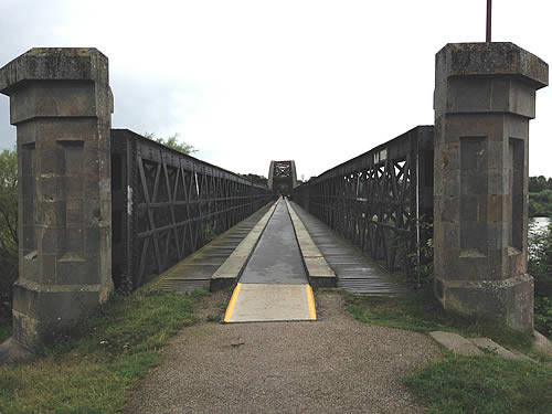
The Spey Viaduct, Moray, now part of the National Cycle Network. The fixings for the railway telegraph wires can be seen either side of the main span (Bob Prigg)
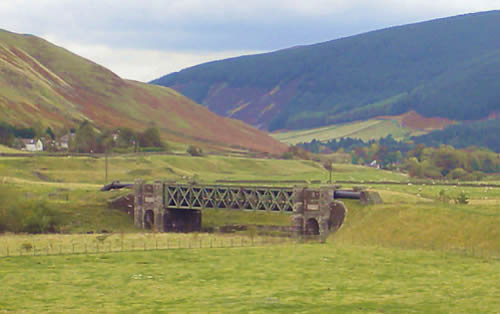
The main line through Killin Junction ran from Callander to Crianlarich. The 12 arch Glen Ogle Viaduct now carries a high quality cycle trail. May 2006. (Bob Prigg)
This photograph shows the new surface on the deck of Glen Ogle Viaduct. May 2006 (Bob Prigg)
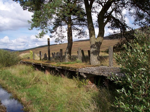
This classic view of Glen Ogle Viaduct in the landscape makes it very clear why such a structure was needed here. (Bob Prigg)
Big Water of Fleet Viaduct. An impression of the viaduct’s size can be gained from the shadows straddling the valley below. As can seen, the viaduct was strengthened with bricks and old rails to cope with the volume of traffic that formerly used it (Bob Prigg)
Loch Skerrow Halt was a passing loop on the line between Big Water of Fleet and Castle Douglas. Because of the loop, it was provided with a signal box and water tower, although the locality remains very remote (Bob Prigg)
Glenluce Viaduct about 8 miles east of Stranraer, is another striking feature on the Port Road, which is notable almost throughout for its extensive engineering (Bob Prigg)
The Caledonian Railway’s Leith North branch is of Lindsay Road Bridge, a gently curving girder structure on stone piers situated between Granton Road and the Leith North terminus (Ralph Rawlinson)
Granton Gas Works station. Just west of Granton Road station, a freight-only branch headed north to serve Granton Gas Works and Granton Harbour (Ralph Rawlinson)
This exterior view of Alnwick station shows the large train shed, which still possesses its ventilation windows visible on the left and right of the roof. The station was a terminus, with lines fanning out east to Alnmouth and north to Coldstream and eventually Berwick (Bob Prigg)
The Talla Railway’s bridge over the River Tweed survives intact. It is situated at Glenrusco, near Tweedsmuir, just before the line swings around Cockiland Hill (seen in the left distance) on its final approach to the dam at the north end of the reservoir. October 2009 (Richard Lewis)
The Spey Viaduct, east of Garmouth, marks the start of a long coastal stretch of NCN1. 2015 (Robert Greenall)
This striking photograph was taken from within the bowstring part of the viaduct. 2015 (Robert Greenall)
Maud, a remote but once thriving junction in north-east Scotland where trains from Aberdeen to Peterhead and Fraserburgh would diverge. 2015 (Robert Greenall)
The fishing village of Cullen, on the Moray Firth. The viaduct is part of the Elgin to Cairnie Junction line, which winds over the village on a series of these fine structures. 2015 (Robert Greenall)
This bridge over the River Kelvin was the main engineering feature on the short Dawsholm branch. In connection with Kirklee station; it is one of 5 bridges that crossed the River Kelvin within half a mile. 22016 (Chris Jennings)
The viaduct approaching Glasgow St. Enoch’s, which closed in 1966 and was demolished in 1977. The viaduct which carried the railway into St. Enoch’s station from the north. This is the view at the junction of Osborne Street and King Street.
Glasgow St. Enoch’s closed in 1966 and was demolished in 1977. 2016 (Chris Jennings)
A view along Osborne Street of the former viaduct by which trains bound for St. Enoch’s accessed the station. 2016 (Chris Jennings)
A view of the former Glasgow underground station at St. Enoch’s. The glass structure catching the light behind this building is the modern entrance to this subway station. 2016
(Chris Jennings)
The island platform of Crow Road station has an almost subterranean look about it, accentuated by the wide road overbridge which crosses it. The station’s gloomy appearance reflects the fact that it was served by a railway built largely in tunnels and cuttings. 2016 (Chris Jennings)
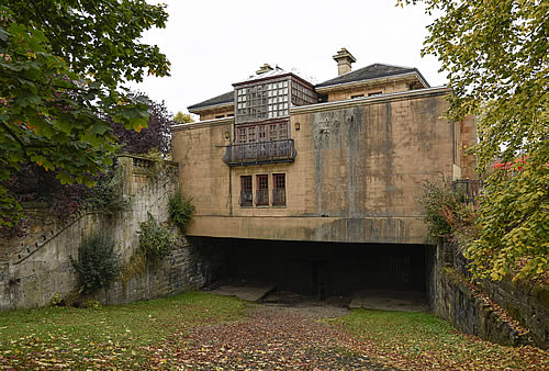
This disused station is Kelvinside, which was reached after a tunnel of the same name; Kelvinside station has survived very well, having been converted into a restaurant. 2016 (Chris Jennings)
The rear view of Kelvinside station spans the old railway formation. 2016 (Chris Jennings)
Kelvinside Station and evidence of the covered staircase which led down to platform level, etched into the cutting wall. As can be seen, the trackbed here has been partially infilled, and sloped access created. 2016 (Chris Jennings)
 The Spey Viaduct, Moray, now part of the National Cycle Network. The fixings for the railway telegraph wires can be seen either side of the main span (Bob Prigg)
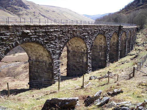 The main line through Killin Junction ran from Callander to Crianlarich. The 12 arch Glen Ogle Viaduct now carries a high quality cycle trail. May 2006. (Bob Prigg)
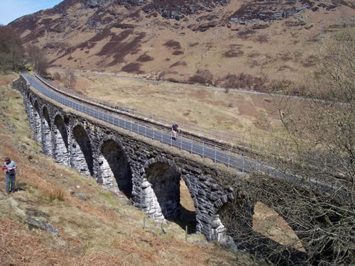 This photograph shows the new surface on the deck of Glen Ogle Viaduct. May 2006 (Bob Prigg)
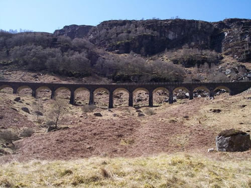 This classic view of Glen Ogle Viaduct in the landscape makes it very clear why such a structure was needed here. (Bob Prigg)
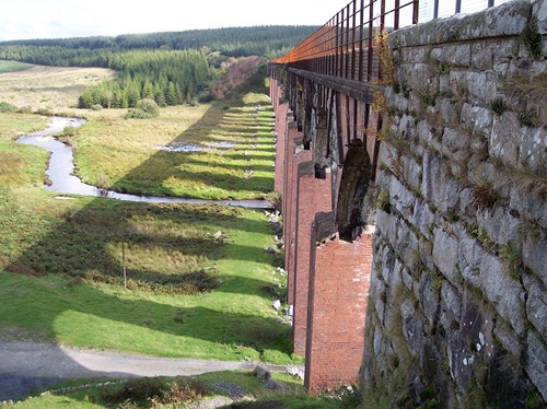 Big Water of Fleet Viaduct. An impression of the viaduct’s size can be gained from the shadows straddling the valley below. As can seen, the viaduct was strengthened with bricks and old rails to cope with the volume of traffic that formerly used it (Bob Prigg)
 Loch Skerrow Halt was a passing loop on the line between Big Water of Fleet and Castle Douglas. Because of the loop, it was provided with a signal box and water tower, although the locality remains very remote (Bob Prigg)
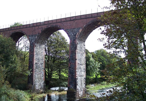 Glenluce Viaduct about 8 miles east of Stranraer, is another striking feature on the Port Road, which is notable almost throughout for its extensive engineering (Bob Prigg)
 The Caledonian Railway’s Leith North branch is of Lindsay Road Bridge, a gently curving girder structure on stone piers situated between Granton Road and the Leith North terminus (Ralph Rawlinson)
 Granton Gas Works station. Just west of Granton Road station, a freight-only branch headed north to serve Granton Gas Works and Granton Harbour (Ralph Rawlinson)
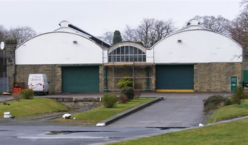 This exterior view of Alnwick station shows the large train shed, which still possesses its ventilation windows visible on the left and right of the roof. The station was a terminus, with lines fanning out east to Alnmouth and north to Coldstream and eventually Berwick (Bob Prigg)
 The Talla Railway’s bridge over the River Tweed survives intact. It is situated at Glenrusco, near Tweedsmuir, just before the line swings around Cockiland Hill (seen in the left distance) on its final approach to the dam at the north end of the reservoir. October 2009 (Richard Lewis)
 The Spey Viaduct, east of Garmouth, marks the start of a long coastal stretch of NCN1. 2015 (Robert Greenall)
 This striking photograph was taken from within the bowstring part of the viaduct. 2015 (Robert Greenall)
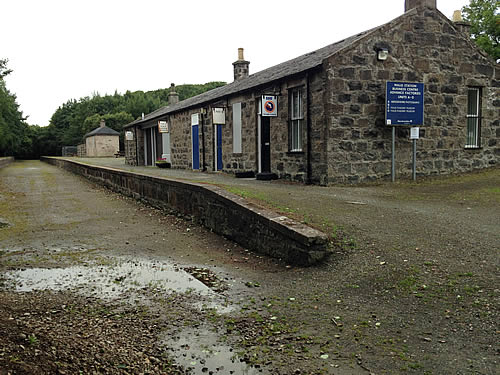 Maud, a remote but once thriving junction in north-east Scotland where trains from Aberdeen to Peterhead and Fraserburgh would diverge. 2015 (Robert Greenall)
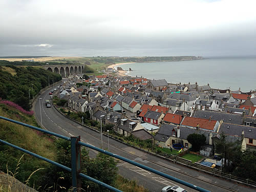 The fishing village of Cullen, on the Moray Firth. The viaduct is part of the Elgin to Cairnie Junction line, which winds over the village on a series of these fine structures. 2015 (Robert Greenall)
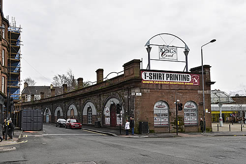
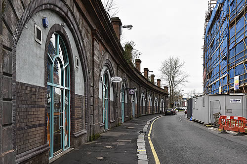
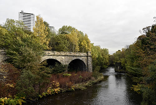 This bridge over the River Kelvin was the main engineering feature on the short Dawsholm branch. In connection with Kirklee station; it is one of 5 bridges that crossed the River Kelvin within half a mile. 22016 (Chris Jennings)
 The viaduct approaching Glasgow St. Enoch’s, which closed in 1966 and was demolished in 1977. The viaduct which carried the railway into St. Enoch’s station from the north. This is the view at the junction of Osborne Street and King Street.
Glasgow St. Enoch’s closed in 1966 and was demolished in 1977. 2016 (Chris Jennings)
The viaduct approaching Glasgow St. Enoch’s, which closed in 1966 and was demolished in 1977. The viaduct which carried the railway into St. Enoch’s station from the north. This is the view at the junction of Osborne Street and King Street.
Glasgow St. Enoch’s closed in 1966 and was demolished in 1977. 2016 (Chris Jennings)
 A view along Osborne Street of the former viaduct by which trains bound for St. Enoch’s accessed the station. 2016 (Chris Jennings)
 A view of the former Glasgow underground station at St. Enoch’s. The glass structure catching the light behind this building is the modern entrance to this subway station. 2016
(Chris Jennings)
A view of the former Glasgow underground station at St. Enoch’s. The glass structure catching the light behind this building is the modern entrance to this subway station. 2016
(Chris Jennings)
 The island platform of Crow Road station has an almost subterranean look about it, accentuated by the wide road overbridge which crosses it. The station’s gloomy appearance reflects the fact that it was served by a railway built largely in tunnels and cuttings. 2016 (Chris Jennings)
 This disused station is Kelvinside, which was reached after a tunnel of the same name; Kelvinside station has survived very well, having been converted into a restaurant. 2016 (Chris Jennings)
 The rear view of Kelvinside station spans the old railway formation. 2016 (Chris Jennings)
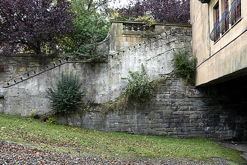 Kelvinside Station and evidence of the covered staircase which led down to platform level, etched into the cutting wall. As can be seen, the trackbed here has been partially infilled, and sloped access created. 2016 (Chris Jennings)