

|
Menu
|
|
|
|||||||||||||||
|
|
|||||||||||||||
145
|
146 |
147 |
148 |
149 |
150 |
151 |
152 |
153 |
154 |
155 |
156 |
157 |
158 |
159 |
160 |
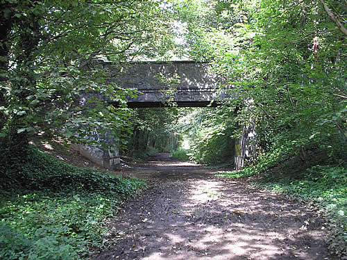 |
| Above: Part of NCN5 occupies a section of the former LNWR route from Lichfield Line Junction to Pelsall, where separate lines diverged to Hednesford and Lichfield. This is Railswood Drive overbridge at Pelsall, just north of where NCN5 leaves the trackbed. August 2009. (Phil Mullarkey) |
 |
| Above: Norton Branch Junction, just north of Pelsall, was where the lines to Hednesford and Lichfield diverged, that to Hednesford being known as the Norton Branch. The bridge depicted here, at SK 033052, once carried the Norton Branch over the the Wyrley and Essington Canal. August 2009. (Phil Mullarkey) |
 |
| Above: At Norton Junction, Pelsall, the South Staffordshire Line continued towards Lichfield, crossing the Wyrley & Essington Canal at SK 039052. The W&EC is a contour canal which follows contours to avoid heavy engineering works; the resultant meandering course explains why it is known locally as the 'Curly Wyrley'. The distinctive parapets on this disused railway bridge are of a type that crops up widely on railway walks, so it would be interesting to know who cast them. August 2009. (Phil Mullarkey) |
 |
| Above: A close up of the iron panels seen in the rail-over-canal bridge illustrated above. They don't make 'em like that any more! August 2009. (Phil MUllarkey) |
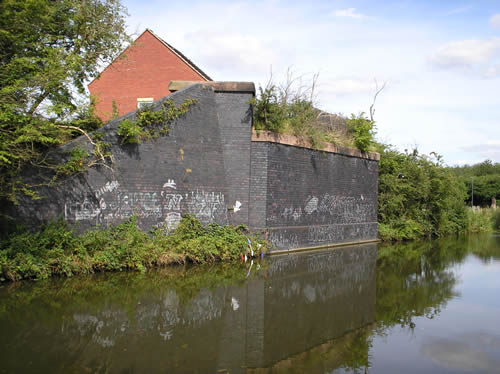 |
Above: Near Brownhills, the South Staffordshire Line from Pelsall to Lichfield was crossed by the Midland Railway's branch from Aldridge to Brownhills West and Conduit Colliery. The bridge seen above, another railway crossing of the 'Curly Wyrley', is on the MR line at SK 042052, but it has not been so lucky as the South Staffordshire bridge seen above. No doubt the span was a metal one which had value to scrap merchants after the line closed. The preserved Chasewater Railway now occupies the MR trackbed from Brownhills West station northwards. August 2009. (Phil Mullarkey) |
 |
Above: 'Kirby Moorside Valediction'. The market town of Kirby Moorside (or Kirkbymoorside, according to the OS) was situated on the NER branch line from Pickering to Pilmoor, on the East Coast Main Line north of York. It lost its passenger services on 2nd February 1953, although freight and fairly regular excursions (for shopping, football, rambling, etc.) continued between here and Pilmoor until 1964. Upon closure, the site was taken over by a farming products and machinery company (the station's biggest customer during its declining years) which remained there until 2008. The buildings still looked in fine repair 55 years after the last scheduled passenger train had departed. 12th October 2008. (Sharon Feely) |
 |
| Above: This is the platform side of Kirby Moorside, viewed on the same day from the nearby road-over-rail bridge. The trackbed has been filled in to platform level, presumably for safety reasons. 12th October 2008. (Sharon Feely) |
 |
| Above: A similar view of the station, again looking east towards Sinnington and Pickering. The trackbed beyond the station site is blocked by light industrial development. The Pilmoor-Pickering line was single track with passing places, one of which was situated here: passengers for Pilmoor, Thirsk and York – all served by direct trains from Kirby Moorside – used a second platform which once stood on the right of this picture. 3rd September 2008. (Benjamin Hughes, used under the terms of the Wikimedia Commons licence) |
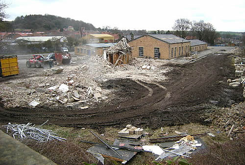 |
| Above: And now for the bad news. According to Wikipedia, Kirby Moorside station was demolished at the end of March 2010. Like many rural stations, especially those serving now rail-less market towns, it occupied a large plot of land which eventually became irresistible to developers. A station site as large as this can accommodate half a dozen large industrial warehouses, or a sizeable housing development – very sizeable if the new homes have minimal gardens and are shoe-horned in, as seems to be the practice nowadays. Our photographer reports that new homes are to be built here, and she thinks it is only a matter of time before the surviving goods shed and weighbridge hut are demolished too. The eradication of all this local transport history is particularly sad because, until this happened, the entire site had survived almost unaltered since closure. Click here for a view of the station in its heyday. 2nd April 2009. (Sharon Feely) |