

|
Menu
|
|
|
|||||||||||||||
|
|
|||||||||||||||
145
|
146 |
147 |
148 |
149 |
150 |
151 |
152 |
153 |
154 |
155 |
156 |
157 |
158 |
159 |
160 |
Photographs by Chris Jennings (continued). We conclude Chris's photographic selection with some images taken on 14th March 2015 during a club walk that traced the former Preston & Longridge Railway, a private company that ended up under the joint control of the Lancashire & Yorkshire and London & North Western Railways. The line lost its passenger service as long ago as 2nd June 1930, but freight continued until November 1967. Even then, the line wasn't entirely finished thanks to a Courtaulds factory at Red Scar, which continued to supply traffic into Preston and beyond until 1980. Between Preston's Blackpool Road and Red Scar, the trackbed is now a multi use trail, which has long been the subject of a planned extension to Grimsargh; it wouldn't take much, for the current OS Explorer map (July 2015) shows the route stopping less than half a mile short of Grimsargh village. Within the confines of Preston, this is a highly urban route which strikes a marked contrast with the disused rural lines that feature so often on these pages. There's a tremendous zoomable map here which shows the the tangle of lines that used to exist around Preston. |
||
 |
||
| Above: These rail overbridges, just north of Preston station, carry Maudland Bank and Leighton Street over the top of the old Longridge branch line; the grid reference is SD 532298. 14th March 2015. (Chris Jennings) |
||
 |
||
| Above: This photograph illustrates the scene above, eight years earlier. A comparison quickly reveals the extent to which nature is reclaiming her own. 12th August 2007. (Betty Longbottom, used under the terms of this Creative Commons licence) | ||
 |
||
| Above: Moving east along the line, this is the west portal of Deepdale (or Miley) No. 1 Tunnel. It is 160 yards long and runs beneath a terrace of houses on the south side of St Peter’s Square, which – rather confusingly – is actually a road rather than a square; the 'No Entry' signs in the middle left of the photograph marks its western end. 14th March 2015. (Chris Jennings) | ||
 |
||
| Above: Boundary markers at grid reference SD 545303 in Deepdale Road, near its junction with Burrow Road. Look carefully at the edging stones and you will be able to make out the widely-spaced initials 'LNW & L&Y RY COS'. The line passed under Deepdale Road via a rail overbridge, but the railway company owned a small piece of land at the road junction behind its bridge parapet, which it marked in this way as its own. 14th March 2015. (Chris Jennings) |
||
 |
||
| Above: The arch of this pedestrian footbridge, also in Deepdale, recalls the vernacular style of local canal bridges, which is hardly surprising when one considers that the P&LR was set up in 1836 and opened in 1840, with horses as the motive power. The bridge is charming even if the amount of waste on the trackbed is not! Surely this old railway would be more valued by the local community, and in a better state, if it were re-used as a trail? If you look carefully in the lower middle foreground, you can just make out a section of rail, for the permanent way remains in place all the way from Preston to Red Scar. 14th March 2015. (Chris Jennings) | ||
 |
||
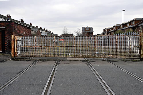
| Above: Although no trains have traversed the line for some 35 years, Deepdale Junction still retains its level crossing gates (after a fashion) plus a complete set of rails and check rails. This is where a 33 chain spur back to Deepdale Goods diverged from the main branch. The location is SD 551305 on Skeffington Road. 14th March 2015. (Chris Jennings) | ||
 |
||
| Above: Despite closing its doors to passengers in June 1930, Ribbleton station still clings to life. In 2007, it was boarded up and ruinous, but the evidence of clearance work in the foreground suggests that someone might be trying to save it. This is one of those stations where the railway couldn't quite decide on the name. Opened in 1854 as Gammer Lane, it was changed to Fulwood in 1856 before finally becoming Ribbleton in 1900. 14th March 2015. (Chris Jennings) | ||
|
||
 |
||
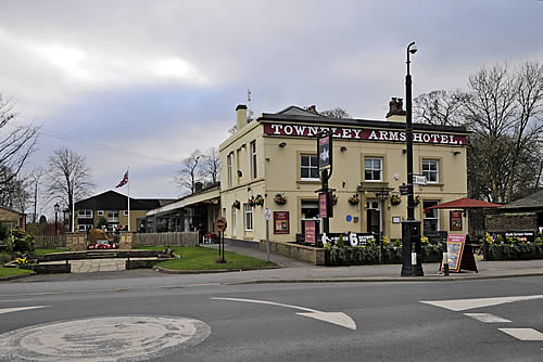
| Above: After some of the foregoing scenes, it comes as a relief to reveal that the old station at Longridge survives in fine fettle, adjoining the recently refurbished Towneley Arms Hotel. Behind the hotel, the station canopy can be seen clearly, with the town's war memorial now standing opposite on the former trackbed. The adjoining station buildings (under and beyond the canopy) now serve as the headquarters of Longridge Town Council, as well as a heritage centre and community area; their restoration was achieved with the aid of a £221,600 grant from the Heritage Lottery Fund in late 2008. 14th March 2015. (Chris Jennings) |
